


The Ontong Java Plateau (OJP) is a massive oceanic plateau located in the southwestern Pacific Ocean, north of the Solomon Islands. The OJP has formed around 120 million years ago with a much smaller volcanic event around 90 million years ago.

The eruption produced about 100 million cubic kilometers of basalt (i.e. 100 MILLION times more magma than Mt St. Helens in 1980) and covered about 1% of the earth’s surface, creating the largest oceanic plateau. Tectonic movements split the original plateau into the present-day’s Onto Java Plateau, the Manihiki Plateau east of Samoa, and the Hikurangi Plateau east of New Zealand’s North Island.
OJP is bounded by Lyra Basin to the northwest, East Mariana Basin to the north, Nauru Basin to the northeast, and the Ellice Basin to the southeast. The OJP has collided with the Solomon Islands island arc and now lies on the inactive Vitiaz Trench and the Pacific–Australian plate boundary. OJP has a volume of more than 5 million km3.
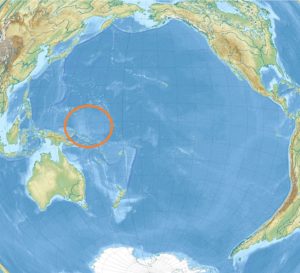
Most of the plateau was formed underwater and submerged, but a tectonic collision with the Solomon Island Block has caused parts of the Ontong Java Plateau to be uplifted above sea level. This includes the islands of Makira, Malaita, and the northern half of Santa Isabel, as well as the smaller islands of Ramos and Ulawa. Several large volcanic seamounts arise from the plateau, including the one capped by Ontong Java Atoll (which gave the name to the lava plateau).
According to Wikipedia/ volcanodiscovery
 Royal Flying Doctor Service: World’s oldest aeromedical service")
 Canning Stock Route: The longest historic stock route in the world")
 New Caledonian giant gecko: The largest extant gecko in the world")
 Michael Smith: World’s first person to solo navigate the world in a single-engine flying boat")
 Melbourne University Lacrosse Club: The oldest continuously existing lacrosse club in the world")